Free with a fleet account · no card
Truck route planner
Multi-stop routes calculated for your truck's height, weight, width and cargo — with the breaks the law requires worked out along the way, and one tap to send it to a driver's phone.
- Routes around low bridges, weight and width limits
- EU 561/2006 breaks placed at real stops
- Up to 12 stops — delivery, fuel, rest, parking
- Built from your saved truck profiles
Two minutes: confirm your email, add a truck, plan. Live tracking starts a 3-day free trial when you want it.
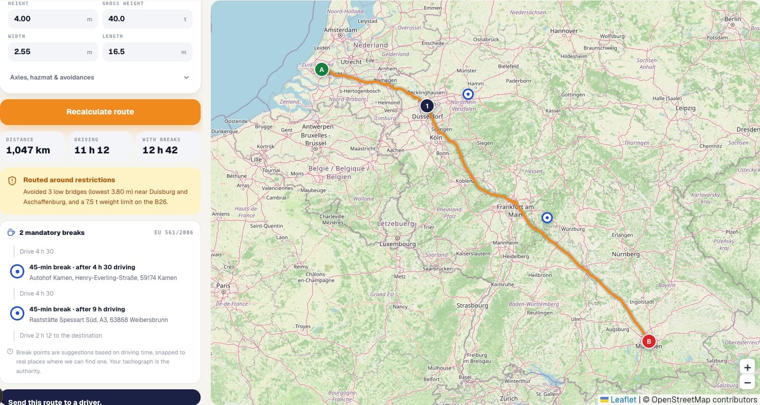
Why a car route planner gets trucks stuck
A consumer navigation app plans for a vehicle about 1.5 m tall and 2 tonnes. It has no field for your height and no reason to hold the restriction data that would matter if it did. So it returns the fastest line between two points — down a lane with a 7.5-tonne limit, or under a railway bridge lower than your trailer.
A truck route planner starts from the vehicle instead of the road. Save height, gross weight, width, length and axle count once and every candidate road is checked against them before it can appear in your route. Add a tunnel category or a hazmat class and whole corridors disappear from the options, because they are closed to that load by law.
Multi-stop routes and the order of them
Real work is rarely one origin and one destination. Add up to ten stops between the two — each marked as a delivery, fuel, rest or parking stop — and the planner routes through them in the order you list. Drag them to change it, and the distance, driving time and break schedule all recalculate together. Fuel stations, truck stops and rest areas can be searched along the corridor and dropped straight into the route.
Breaks are part of the plan, not an afterthought
Under EU Regulation 561/2006 a driver may drive 4 hours 30 before taking a 45-minute break, and no more than 9 hours in a day (10 hours twice a week). A route that looks like 11 hours of driving is really a two-day job, and planning as though it is not is how loads arrive late. The planner marks each break at the point the clock runs out, on a real place to stop where it can find one, and checks the run against the driver's remaining hours before you send it.
From plan to the driver's phone
Planning is free. When you want the route driven, a 3-day free trial puts the truck on your live map: the route goes to the driver in the Navitruck app, which carries the same routing engine, warns before every restriction even in the background, and works offline. Restriction data, however extensive, is never complete: read the signs.
Common questions
Is the truck route planner free?+
Yes, with a free fleet account. Confirm your email and plan as many multi-stop truck routes as you like, for up to five truck profiles, with no card. Live tracking, driver connections and dispatch to drivers' phones start with a 3-day free trial.
How does it avoid low bridges and weight limits?+
You save your truck's height, gross weight, width, length, axle count and cargo class once, and every route is calculated against truck restriction data for those exact numbers — low bridges, weight-limited roads, narrow streets, no-truck roads, plus ADR tunnel categories and hazmat bans.
How are the driving breaks calculated?+
Break points follow EU Regulation 561/2006: a 45-minute break after 4 hours 30 of driving, then again every 4 hours 30. We place each break at that point on your route and snap it to a real place where one can be found. Your tachograph remains the authority.
How many stops can I add?+
Up to twelve per route — a start, a destination and ten stops in between, each marked as a delivery, fuel, rest or parking stop. Drag stops to reorder them; the route and break schedule recalculate together.
Which countries are covered?+
Truck routing and restriction data cover more than 100 countries across Europe, North and South America, Africa, Asia and Oceania. Restriction coverage depends on each country's road data.
Take the routing on the road
The app plans the same truck-safe routes, then warns you before every low bridge, weight limit and camera — even in the background, even offline.